
NWS-Topeka graphic (Friday 3 p.m.)
MANHATTAN — The Manhattan area is on the edge of a potential blizzard that could make travel hazardous Saturday.
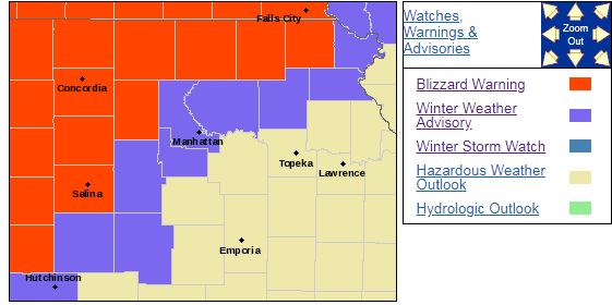
The National Weather Service has issued a Winter Weather Advisory for Riley, Pottawatomie and Geary counties from 3 p.m. Saturday to midnight. Snow, occasionally mixed with freezing rain will be possible. Total snow accumulations of up to two inches and ice accumulations of a light glaze are anticipated. Winds are expected to be very strong, gusting as high as 45 miles per hour at times. Slippery roads and reduced visibility will be likely at times due to blowing snow.
Blizzard warnings will go into effect for Clay, Marshall and Washington counties by Saturday afternoon through midnight, extending west toward Concordia, where the heaviest snowfall is expected. Those areas could see as much as 4 to 6 inches of snow.
The National Weather Service says this has been a difficult storm to forecast because of uncertainty of where the low pressure center will be.
Saturday’s system will begin as rain, changing over to snow by mid-afternoon, but no freezing rain is anticipated during the change over. There could be some freezing precipitation on the back end of this system, according to the NWS. Snow will begin falling in Manhattan by around 3 p.m. to 6 p.m. but could start sooner in northern portions of Riley County.
The City of Manhattan also is reminding residents to make sure they remove snow from city sidewalks in a timely manner (see below video).
The post Here we snow again appeared first on News Radio KMAN.