
NWS Topeka graphic
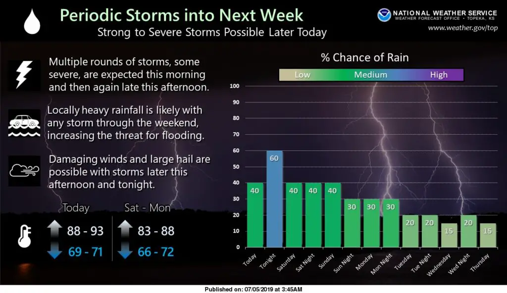
The long holiday weekend forecast has some increased chances for rain and periodic thunderstorms, especially on Friday.
Storm activity developed in the morning hours and forecasters say redevelopment is possible later in the afternoon or evening. Some of that activity, especially in the evening could spawn severe storms, with the potential to produce damaging winds and large hail. Any storm this weekend has the potential to produce heavy rainfall, which could lead to flooding, especially in low-lying areas.
River flooding also continues due to reservoir backflow and heavy rains Thursday. Flood warnings were posted Friday morning for the Kansas River affecting Geary and Riley counties and at Manhattan, affecting Pottawatomie, Riley and Wabaunsee counties. The Kansas River at Manhattan was at 15 feet Friday morning and forecast to crest at 19.4 feet by Sunday afternoon. Minor flooding occurs at 18 feet.
Tuttle Creek Lake fell overnight to 1,129.89 feet. Inflow to the lake is 7.800 cubic feet per second and outflow from the tubes continues to be at 16,000 CFS. The three-day forecast shows the lake maintaining an average level right around 1,129 feet.
Chances of rain continue through the weekend and then will begin to dissipate by Tuesday.
The post On and off storm chances continue Friday and through the weekend appeared first on News Radio KMAN.